|
| |
WXtrack in full ISS mode
From: Michel Casabonne
From: George Papadopoulos
|
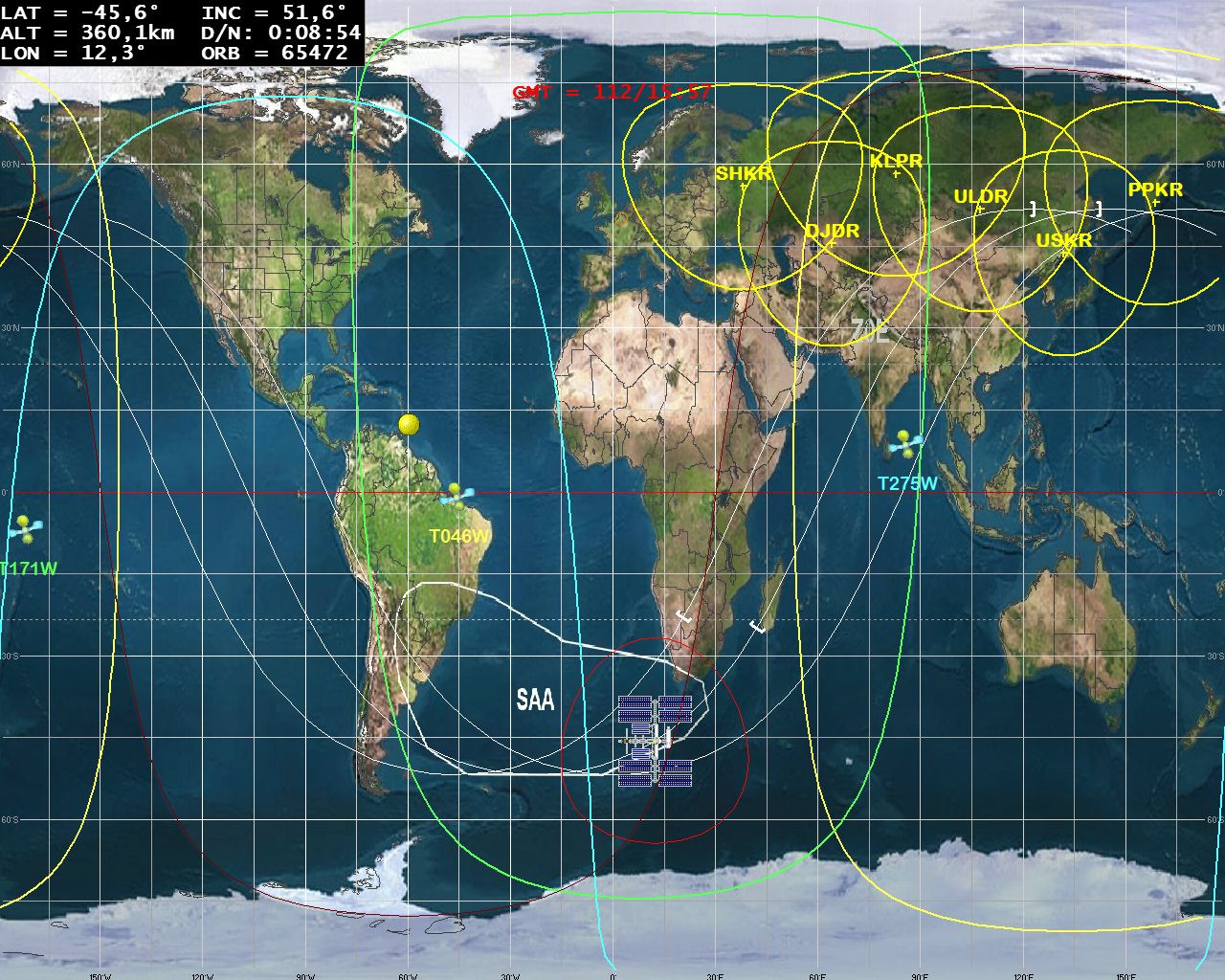
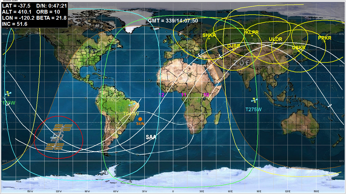
In recent versions WXtrack there are a
number of enhancements which allow you to produce a display very similar to that
in the NASA ISS Mission Control
Room. Many of these were suggested by
Michel Casabonne, to whom I am very grateful. Some of these options are
only available in the registered
version of WXtrack, and require release V3.8.6.934 or later. Above you
can see
Michel Casabonne's and George Papadopoulos' examples of using full ISS mode.
-
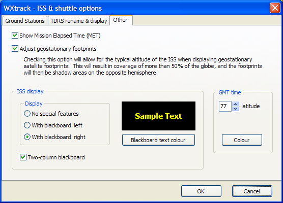
One-column or two-column
"blackboard" display.
-
GMT display (shown in red above).
-
Mission elapsed time display.
-
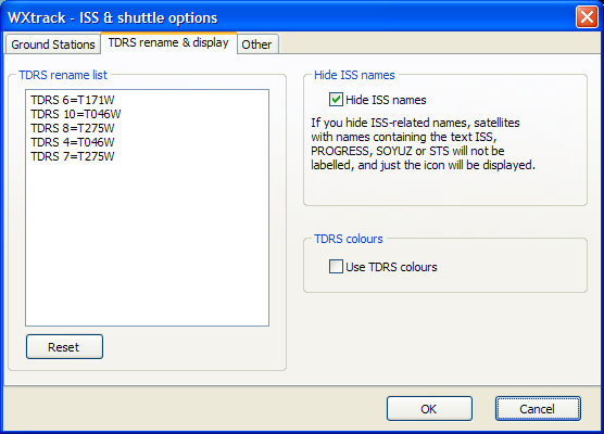
Custom icons from Michel Casbonne for the ISS
and the TDRS communications satellites.
-
Custom labels, label colours and footprint colours for the TDRS satellites
- you can rename TDRS-7 to T275W independent of the name in the Kepler data.
The labels will be shown horizontally and not diagonally as is normal for geostationary
satellites.
-
Hide the names of ISS-related objects and
just show the icon.
-
Correct display of footprints for
geostationary satellites as seen from the ISS. (As the ISS is well
above the ground, the "footprint" of a geostationary satellite
will be greater than normal, and will extend to the far side of the earth as
seen from the geostationary satellite.)
-
South Atlantic Anomaly (SAA) shown on
Michel's custom
background map.
-
Intermediate latitude and longitude lines on
background map.
-
Ground track displayed 1.5 orbits back and
1.5 orbits forward.
-
Entry to and exit from eclipse periods marked
on ground track. These are D/N (day/night) values on the blackboard display.
-
Near full-screen view with F11 key or
right-click pop-up menu. On my system I still see a tiny remnant of
the "World Map" tab sheet label, and I hope it does not spoil your
enjoyment of near-full screen view.
-
Country boundaries can be displayed in Plate-Carrée
mode.
-
Extra Tools, ISS Weather, menu for display of
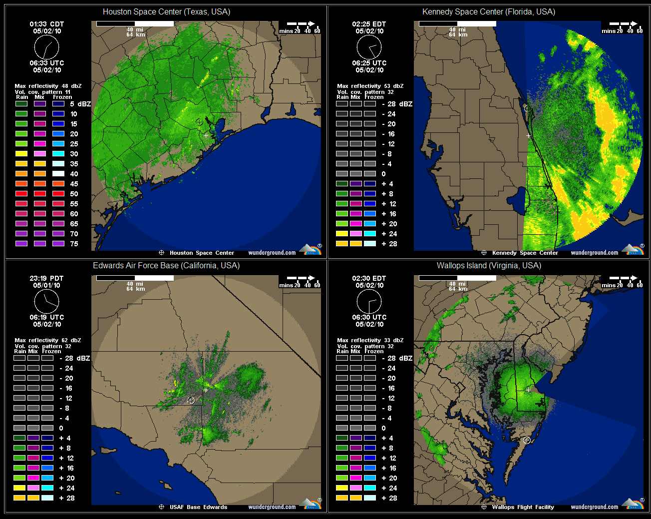
real-time weather at US landing locations in your Web browser...
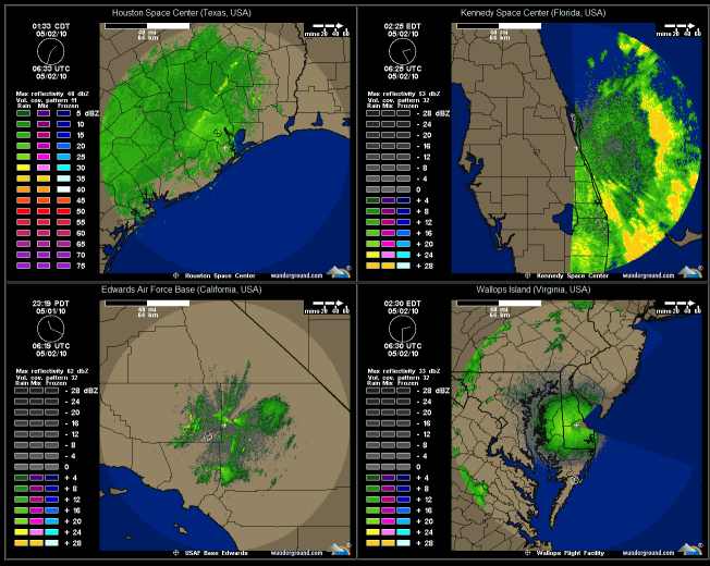
(Click for full-size sample)
|
Michel kindly also contributed a French
translation of the software description.
Back to WXtrack information
ISS Options
|
Here are some of the options you can set for the
ISS - they are not the options used for the screen-shot above.
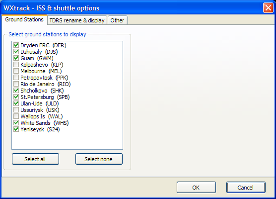
Please note that to have the TDRS plotted,
you will need to select them as Active satellites for the bank you are
using. I don't know how to determine which TDRS satellites are used
at any particular time.
|
Back to WXtrack information
WXtrack in full ISS mode
... em Portuguęs
|
Nas recentes versőes do WXtrack, há uma série de melhorias que permitem produzir uma exibiçăo muito semelhante aquela verificada na
Sala de Controlo da Missăo da ISS da NASA. Muitas delas foram sugeridas por Michel Casabonne, a quem estou muito grato. Algumas destas opçőes só estăo disponíveis na
versăo registrada do WXtrack e exigem V3.8.6.934, com autorizaçăo.
-
Uma ou de duas colunas de exibiçăo de parâmetros " negro " .
-
Indicaçăo da Hora GMT (mostrado em vermelho
acima).
-
Visualizaçăo da hora da Missăo a decorrer
-
Ícones personalizados de “Michel
Casbonne” para a ISS e os satélites de comunicaçőes TDRS.
-
Identificaçăo personalizada e a cores para os satélites TDRS visíveis - Pode mudar de TDRS -7 para T275W independente do nome nos dados do Kepler. As identificaçőes serăo exibidas na horizontal e năo na diagonal como é normal para satélites geoestacionários.
-
Ocultar os nomes de objectos relacionados com a ISS e apenas mostrar o ícone.
-
Vista correcta para satélites geoestacionários, tal como vista desde a ISS. (Como a ISS se encontra muito acima do solo, o "footprint" de um satélite geoestacionário é maior do que o normal, e se estenderá até o outro lado da terra como visto do satélite geoestacionário.)
-
South Atlantic Anomaly (SAA) – (Anomalia do Atlântico Sul - AAS), Linha branca mostrada em fundo no
mapa de ” Michel Casbonne”.
-
Latitude Intermédia e linhas de longitude em fundo no
mapa.
-
Visualizaçăo das orbitas em relaçăo ŕ terra, exibindo 1,5 órbitas a percorrer e 1,5 órbitas
percorridas.
-
Entrada e saída das zonas de sombra, períodos marcados no mapa. Trata-se de D / N (dia / noite).
-
Visualizaçăo em ecră completo com a tecla F11 ou no menu pop-up do botăo direito. No meu sistema eu ainda vejo um pequeno resquício no " Mapa do Mundo " da guia da folha. Espero que isso năo estrague o seu prazer de quase completa visualizaçăo do ecră.
-
Os limites dos países podem ser exibidos em modo Plate- Carrée .
-
Ferramentas extras: ISS Tempo, menu para exibiçăo de meteorologia em tempo real em locais de desembarque dos EUA no seu browser ...
(Click for full-size sample)
|
Michel kindly also contributed a French
translation of the software description.
Voltar para as informaçőes do WXtrack
ISS Options
|
Aqui estăo algumas das opçőes que podem ser configuradas para a ISS - năo săo as opçőes utilizadas para a captura do ecră
acima.
Por favor, note que para planear ter os TDRS, precisará de os seleccionar como satélites activos, para o banco que vocę está usar. Caso contrário, năo saberá determinar quais os satélites TDRS que estăo a ser usados em qualquer momento específico.
|
Voltar
para as informaçőes do WXtrack
Translation by: Eduardo Mata, thanks! |