|
| |
WXtrack - Satellite tracking
Information WXtrack em Portugu�s.
What the reviewers and users have said:
- ".. a lovely piece of software" - Dave Garton,
Satellite Applications Catapult, UK
- "WXtrack is free, and is one of the best tracking
programs that I have come across" - Radio Active April 2001
- "...a satellite tracking program with a superbly crafted
tracking window..." - Remote Imaging Group Journal 58
- "...as up to date as any...", "...an impressive program..."
- Monitoring Times, August 1999
- "..the excellent "WXtrack" software .... I've used WXtrack in various outreach programs
to high schools and recommend it." - Professor Bill
Cowley, Director,�Institute for Telecommunications Research, Satellite Comms Program Leader, CRC for Satellite
Systems
- "It was a pleasure to find a well-crafted package"
- MD Robotics -
makers of the Canadarm used on the Space Shuttle and Station
- "I have used your program quite a bit now and I absolutely love
it. It is the best tracking program I have ever used and I have used
them all I am sure :)" - Mark Kyle
- "WXtrack is, by far, the most economical, flexible, and
informative satellite tracking and display package available today. It
will be prominently displayed in our Data Processing Center to show the current, historical, or future location of our "A-Train" satellites and
tracking sites. Kudos to David Taylor for an exceptional satellite application"
- Don Reinke,
NASA CloudSat Mission Data Processing
Center. (CIRA)
- "I wrote Quiktrak and for years it was the mainstay of the amateur and in some cases professional tracking world.
After seeing WXtrack, there is no need for me to ever revisit that offering. I am happy to register this
software" - Bob McGwier, N4HY. Vice President for Engineering, AMSAT-NA
- "WXtrack is a great program - I believe to be the best
available." - Kevin Nice, Nice One Publishing Limited
- The best Satellite Tracking program I've ever used and excellent
support - Terry Gaff on Twitter.
- Used at Surrey Satellite Technology.
WXtrack is used by many Universities and satellite enthusiasts
across the world, and is also used within the industry - NASA, Surrey Satellite
Technology. Popular trackers such as GS-232 and WiSPDDE are supported.
If you
would like a custom version for your project, just e-mail
me. See WXtrack in Embarcadero' Delphi
Application Showcase!
 WXtrack download WXtrack download
 WXtrack
registration - help support continued development! WXtrack
registration - help support continued development!
3D display version - WXtrackGL
download
SatCover
download
SGP4 component download
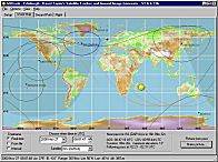
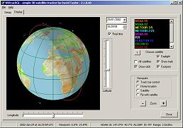
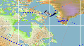
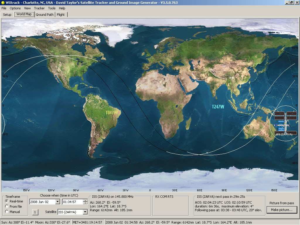
Multiple satellite tracking, with night-time shading.
(Click for more
information)
|
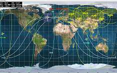
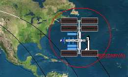
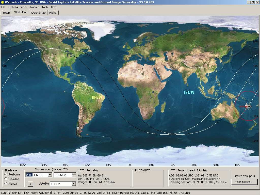
WXtrack in ISS mode, simulating the NASA wall display.
(Click for more
information)
|
This program, which I have described in more detail, is designed to predict the
tracks of satellites both as paths above the earth, and as images produced by
these satellites when scanning the ground. It was designed for use during the early
stages of my weather satellite receiving activities, when clouds and interference prevented easy
identification of what I was actually observing! Read more about using WXtrack. The core orbit
prediction elements are also available as a component that you
can use in your own software. This program is free for amateur use, but if you do wish to say
"thank you", or you want technical support, or you want the
advanced facilities, you should register
WXtrack. |
WXtrack can read processed satellite images from one or more folders of
your choice, and present these images side-by-side with the ground track prediction. To
make visual correlation easier, minute markers are produced on the predicted image to
match those on NOAA APT transmissions. Because of the graphics used in this program,
it really requires a display of 1024 x 768 or better resolution, but it will work on 800 x 600.
Sample of the results
using the full 18MB ground topography database.
Trackers and Antenna Rotators
WXtrack can drive a number of popular antenna tracking systems including
controllers based on the WiSPDDE,
Alfa SPID, AMSAT's LVB tracker, EA4TX's ARSWIN, Kansas City Tracker (RR.DLL
and ON1CIM's KctTracker.exe), Las Vegas Boulevard (LVB from G6LVB), SeaTel, CX6DD (supports
Yaesu GS232), EasyComm, IF-100 and FodTrack standards. There are options for early
startup of the tracker, antenna offset, flip-mode, antenna parking at pass end,
running a command at start-of-tracking etc., and the program has a quick
point-at-object mode for setting up your antenna with the sun, moon etc.
If you have another tracker that you would like supported, why not write to me and ask?
SDR - Software Defined Radio
SDRs are supported both through the excellent HDSDR
software, and the equally good SDR#
software with the DDE add-on.
Users have asked for support on this software, and wish to say
"Thank you", so I now provide extra facilities to users who do register
WXtrack. Commercial use of WXtrack requires purchase of a
commercial licence. The extra facilities are designed to make the program
easier to use for regular users, and to extend the facilities available.
- Extra facilities include
- LARGE TEXT showing the tracker location from the other
side of the room!
- A Satellite Summary form is available by right-clicking
the World Map display - includes MA display, nearest city in addition to
azimuth, elevation range etc.
- The latitude and longitude of the mouse on the World
Map is given in, and the range and bearing from the home location.
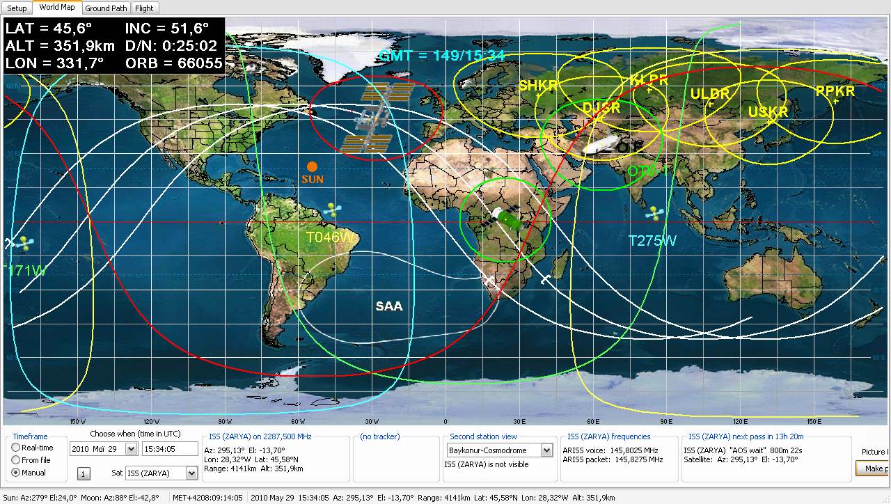
- Display extras e.g. some ISS mode features, multiple
ground station footprint display. Here's a screen-shot
of the registered WXtrack in full ISS
display mode.
- Input from GPS for location and time setting, GPS
prediction mode.
- Extended Radar view functionality, especially for GPS,
- Solar outage times for geostationary satellites - what
are solar outages?
- Satellite priority setting and automatic switch to next
available satellite.
- Option of restricting passes tracked to those in the
pass list.
- Automated daily reload of Kepler data,
- Quick access to Sat
Batch and Kepler Updater through the Tools menu.
- The Tracker Test command is considerably enhanced by
adding offset control, manual positioning and RA/Dec tabs - ideal for tracker setup and
testing.
- The tracker parking option is available.
- Improved precision for some trackers (e.g. 0.1 degrees
for Alfa SPID).
- You can select finer time steps for the pass details
list.
- HRPT channel selection is possible with the G�tz Romahn/Bob Barnes CX6DD tracker variant.
More information about some of
the extra facilities.
Requirements
- System Requirements
- Windows: Windows-7 and 8/8.1 are supported
- Windows XP, Vista are likely to work, but are not
tested here, and are not supported.
- Processor: Pentium 90 or better, 200MHz or better recommended
- Memory: 32MB or better, 64MB highly recommended.
- Display: 800 x 600 resolution or better, 15-, 16- 24- or 32-bit colour
recommended.
- WXtrack works best with Normal font size.
- The runtime Library Bundle listed below is necessary for WXtrack to function. If you get error messages about missing DLLs when
you try to run WXtrack, please consult the library notes page.
- Got a question? Check out the
FAQs.
- There is a free self-help group that you can join here,
where other users of the software can be contacted.
- The Country & State boundary data is required if you wish to
generate image overlays for adding to actual pictures with SatSignal, and for certain map
projections. If you have less than 32MB memory in your system and want to run
overlays, it may be worthwhile downloading the Pre-compiled
overlay bitmap as the program will struggle to generate the 31MB bitmap in a 24MB or
less system! Copy the expanded Overlay.bmp file to the program's executable folder.
If you wish to change grid-line spacing, add longitude and latitude annotation, or
put the grid on top of the countries, please download MakeOverlay program listed under
optional items below.
- If you have a problem with your PC being permanently set on
Daylight Saving time, which happens with certain versions of Windows
98, try the Time Zone Editor
from the Microsoft Windows
2000 Resource Kit. This program, TZEdit, enables you to define your Time
Zone details. More
information.
- If you are driving a tracker in real-time, for more
accurate tracking be sure your PC
is keeping accurate time.
- Updating the Kepler data is the first thing you should do
after downloading. Beware that the file modified date doesn't say how
old the inside the file data is!
Beta version: This program is under continual
development - check here
for the latest update on top of a full install.
|
If you have customised any of the standard
files, be careful not to overwrite your customised files with ones from the
Zip archive! Take the WXtrack.exe, the WXtrack.chm and the
WXtrack.txt first.
Please note that while the Kepler orbit data
supplied with the download was current at the time the download was
prepared, it will be out-of-date by the time you start to use the
program, and you may therefore get a warning about "WXtrack could
find no satellite data".
If that happens, just run the Options, Kepler update... menu function. You are responsible for ensuring that the program has
up-to-date information if you want the most accurate results.
Registered users of the program can achieve this automatically with the Kepler
Updater software, for which their WXtrack licence is also valid.
|
| V3.8.48 |
Add Kepler Updater in Tools menu, remove obsolete Kepler Manager reference, better handling of certain artificial Keplers, improved sort-by-frequency in Kepler view form, add GLONASS and BeiDou to View|RadarPlor (may require Kepler data from CelesTrak), optional display of icon at home location (icon must be in file Home.ico in WXtrack directory, simple sample supplied from Emjois, your choice of size etc., update SPID tracker to all possible gearing options (1� to 0.1�), add short delay after sending a SPID command, add COM ports up to COM22, remember days-to-predict between runs, widen various date/time pickers, add Meteor-M satellites as having an AVHRR-like scanner, add option to close program from the command-line even if tracking, update Help to point to https://groups.io/g/SatSignal and show correct user name, enhanced caption clarity on tab controls, experimental: track geostationary satellites (on Tracker|Options), right-click satellite for larger text on primary, add satellite name & location to caption if tracker options Large track text checked, option for tracker click-on-satellite for frequency change (see: Tracker, Options, Radio, Manual switch), correct country boundary download URL, update Tools|ISS weather URLs, add Tools|My weather for user option URL, correct error when no satellites are assigned to a bank, refine full-screen code (F11).
|
| V3.8.50 |
High visibility choice after satellite font choice
forces bold text and solid background. Get sort Kepler display by age working.
Handle no Kepler data found when all are too old.
|
| V3.8.52 |
Substitute correct URL for "nasabare"
Keplers, change timeline plot non-UTC start point, option for two decimal
digits for greater precision with DDE. Kepler update.
|
|
Please be careful not to overwrite your current Kepler data, or
other local customised data, with
out-of-date info!
Please note that Windows-XP and Vista support has been dropped in versions after
V3.8.26, and although the software should continue to work, it is no
longer guaranteed or supported on older versions of Windows. In
Windows-7 and later it is recommended to install WXtrack into C:\Tools\SatSignal\WXtrack\.
If installed into C:\Program Files\ some
functions will not work.
|
- some functions will not work.Register
WXtrack and help support continued development
- Runtime
Library Bundle (if you don't already have it)
- Got a question - check out the FAQs!
- Optional items
-
Country & State boundary data
(471,178 bytes bytes; 2009 Jun 13, contains the file: countries.dat)
- Pre-compiled overlay bitmap
(421,899 bytes;
2000 May 07)
-
ETOPO5 data can be found on the National
Geophysical Data Center site. Right-click this
link, and save as etopo5.dat. The file is not zipped,
and is quite big at 18MB, and the site speed seems limited - allow a good five minutes!
- NORAD two-line element sets (Keplers) from www.celestrak.com
- Kepler Updater program for
automated Kepler updates.
- For SARAL Kepler elements, download resource.txt
from the CelesTrak Web site. Right-click on the link and use Save Link
as (or similar) to save the file in your WXtrack or Kepler directory.
- SDR# add-on - control radio
frequency on SDRSharp from WXtrack.
- Want to run WXtrack from a Flash drive? by Peter
Pauly explains all about Creating
a Portable WXtrack.
- Orbcomm
update to TLEnotes.txt updates from Craig Orban
-
Satellite frequency and launch date TLEnotes.txt
zip file updates from David
Bate, and his frequencies.ini
file.
- Frequencies.ini
file with 584 satellites from alternative data with 584 satellite frequencies, update 05/01/2014, from:
uhf-satcom.com - Twitter @UHF_Satcom, rename to frequencies.ini before use.
The source which may be more up-to-date is here.
-
WXReceiver program by George
Ioannu - a utility to automatically record the APT signal of passing weather
satellites with RS232 controlled receivers.
- SatTune
program by Tim Seed to control a PCR-1000 radio
- Peter
de Groot's (ON1CIM) KCT server software module (contact Peter directly)
- UserPort
- required for a parallel-port tracker under Windows NT/2000/XP
-
Wave sounds
from Oscar ... for AOS/LOS warnings
- Wave sounds
from Milan Konecny for AOS/LOS warnings (no longer available)
- Wave
sounds from Craig Orban (no longer available)
- 3D display program WXtrackGL
- MakeOverlay program - see
Mapping Tools page
- Want to ask a question - ask the WXtrack
self-help group!
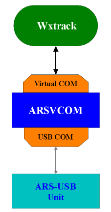 |
The ARSVCOM emulates several interfaces as Yaesu GS232A or Prosistel "D".
So, you don't need to modify anything in WXtrack, because I suppose you already support the GS232A or PST "D".
Just some simple notes about the new ARS-USB Product:
The ARS-USB Product includes the ARS-USB Interface and a program called:
ARSVCOM. Once the ARS-USB Interface is connected into a USB Port (Windows, Linux or MAC OS X) a
serial/COM port is added to the computer (Example: COM5). Without any additional program, any program can use this COM port and send/receive commands from the unit.
The ARS-USB emulates a Yaesu GS232A interface, so it's mandatory that the program send the same commands as a Yaesu GS232A.
If a customer wants to use the ARSVCOM (a graphical and friendly user interface) then he must do as follows:
1 - First, the ARSVCOM can create an additional Virtual COM Port (Example: COM7) and via this virtual COM Port, can emulate several interfaces (GS232, PST "D", etc).
2 - Then, he must configure the ARS-USB Port assigned by Windows (example: COM5) so the program can control the interface.
3 - Finally, configure a 3rd party program (Example: WXtrack) to use the Virtual COM Port (COM7).
Basically, WXtrack will send GS232A commands to the ARSVCOM and those commands will be processed and routed to the USB Port.
(Information kindly supplied by Paolo). |
... em Portugu�s ... Explica��o para o uso do WXtrack com interface USB ARS ARSVCOM
O ARSVCOM emula v�rias interfaces como Yaesu GS232A ou Prosistel "D".
Assim sendo, n�o precisa de modificar nada no WXtrack , porque eu suponho que voc� j� suportam o GS232A ou PST "D".
Apenas algumas notas simples sobre o novo ARS- USB do produto:
O Produto ARS- USB inclui a interface ARS- USB e um programa chamado:
ARSVCOM. Uma vez que a interface ARS - USB � conectada a uma porta USB (Windows, Linux ou Mac OS X) ou a uma porta serial/COM adicionada ao computador, (exemplo: COM5).
Sem nenhum programa espec�fico, qualquer programa pode utilizar esta porta COM e enviar/receber comandos da
unidade. A ARS - USB emula uma interface Yaesu GS232A e por isso � obrigat�rio que o programa envie os mesmos comandos para o Rotor Computer Interface Yaesu GS232A.
Se um operador quer usar o ARSVCOM (uma interface gr�fica e amig�vel), ent�o ele deve fazer o
seguinte:
1 - Em primeiro lugar, o ARSVCOM pode criar uma Porta COM virtual adicional (Exemplo: COM7) e atrav�s desta Porta COM virtual, pode emular v�rias interfaces (GS232, PST " D ", etc).
2 - Em seguida, ele deve configurar a Porta ARS - USB atribu�da pelo Windows (exemplo: COM5) para que o programa possa controlar a interface.
3 - Por fim, configure a 3� parte do programa de (exemplo: WXtrack) para usar a porta COM virtual (COM7).
Basicamente, o WXtrack vai enviar comandos do GS232A ao ARSVCOM sendo os comandos processados e encaminhados para a porta USB.
(Informa��o gentilmente cedida por Paolo).
Translation by: Eduardo Mata, thanks!
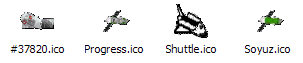
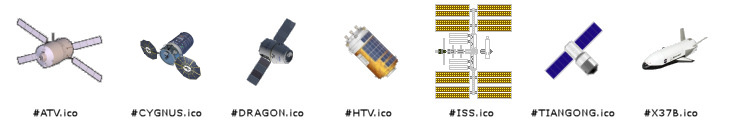
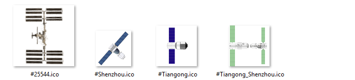
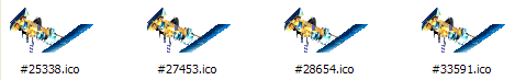
You can download these icons, which have been contributed by
WXtrack users, to show the International
Space Station and Space Shuttle (ISS and STS) on your WXtrack
display. Note that the STS, Progress and Soyuz icons will need to be renamed with the
NORAD catalogue number for each new launch. Copy the contents of
the zip file to your WXtrack directory. My thanks to those who have made
their work available to the WXtrack community. These icons may not
be used with software other than WXtrack without the specific permission of the
icon author. Here's a screen-shot of
the registered WXtrack in full ISS
display mode.
|
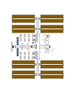
David Davidson STS
& ISS icons
Screen-shot of ISS
and STS icons in use.
The docked icon is in the docked
directory in the Zip archive.
|
(two separate icons)
|
(ISS icon with docked Shuttle)
|
|
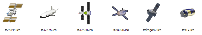
J�rg Fiegge Tiangong 1, Shuttle, Progress
& Soyuz icons
Remember to rename the icons with the NORAD catalogue number
before use (37820 = Tiangong 1). J�rg lives near the home of the first German cosmonaut.
|
|
Michel Casabonne STS,
TDRSS, ISS, and Sun icons
The orange Sun icon requires an icon editor to replace
the MAINICON in WXtrack.exe
Screen-shot
with some of these icons in use.
|
|
Neville Roberts Meteor-M N2 weather satellite icons, choice of five sizes
Download
|
|
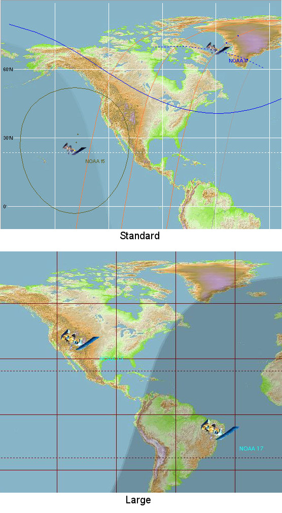
Neville Roberts NOAA
weather satellite icons
Standard
Large
Screen-shot
|
|
|
George Papadopoulos
icons
Includes renovated ISS (and without the STS), Progress,
Soyuz, ATV and reversed shuttle, Hubble, and X38-B. Not all shown here.
George's
icons in use.
|
#25544.ico
|
#25544_STS.ico
|
#meco.ico
|
#sts1.ico
|
#sts2.ico
|
|
George has provided updates to his icons in June 2012.
Yorgos Papadopoulos
earlier update
|
|
|
George Papadopoulos updated
icons Dec-2015 update - including ATV, Cygnus (updated), Dragon, HTV,
ISS, Tiangong and X37B
|
|
|
George Papadopoulos updated
ISS icon ISS Dec-2015 & Oct-2016 updates
|
|
-
Standard world map background My usual world map background
(184 kB, 2022 Nov 02)
- Good quality world map background Good
quality world map background (91 kB, 2000 May 22)
- Higher quality world map with hill shadow
(134 kB, 2000 May 22)
- Darren Mihel
Super-quality world map
with land type colouring & Artic regions. (1.2 MB)
-
Graham
Cox monochrome
world map based on the Earth
Lights at Night image. You may prefer this map if you like a
darker background. (210 kB)
- Justin Priami KG4CEO
super-quality world map
with land type colouring & Arctic regions. (3 MB)
- Large
user map from Terry Gaff (4 MB, 2016-Jul-11)
-
Large "monotone blue hues" user map from Terry Gaff (4 MB,
2018-Feb-21)
- NOAA
clear-sky map (423 kB)
-
Michel Casabonne world map - showing
the South
Atlantic Anomaly (SAA), the region where Earth's inner van Allen radiation belt makes its closest approach to the planet's surface
(836 kB).
- Natural
Earth II
- Tim Makins EI8IC notes:
- You might be interested in my page which
has a few interesting maps for download. Also my programme which lets people make maps
like that themselves. Actually, it really is there to design/edit
.cpt files, which are used in the Generic
Mapping Tools programme, amongst others, but the map routine, which is there to help
visualize .cpt files, does what you want.
If you like this software, you can rate it at the DXZone web site that
lists related programs. Rate this Software @ The
DXZone. Be sure to register
WXtrack and help support continued development.
A self-help group is available for this software:
here
Acknowledgements
I am very grateful to the late Ferran Alegret for providing a Spanish language
version of the help file, which may be obtained directly from his Web site, and to Jean-Louis Fenasse for the
French language help file and information. Thanks to Roger Hedin for his
additions of some lakes and island groups to the original Country & State boundary
data. George Ioannu provided the WXReceiver program for automatically scheduling reception.
David Bate suggested the MET display, and provides data updates. The orbit prediction code was derived from Dr T S Kelso's Pascal units on his CelesTrak web site. Many thanks to Dr Kelso who
very kindly gave permission for his code to be used. A component that can access the
SGP4 model based on Dr T S Kelso's code is available from this page.
Without Dr T S Kelso's code, WXtrack would not have been possible.
|
Click for more
information
|
Imagine that you are flying in space,
looking down upon the Earth. All your favourite satellites are
visible, and you can fly around to your heart's desires. Oh, and it
will cost you nothing! Yes, that's WXtrackGL.
You can choose when and where, and which satellites are displayed.
You can set whether you manually control the program, or get an automated
ride on the satellite!
|
| V2.1.0
|
Updates the program to allow it to act as a
viewer for any data presented on a world-map projection and generalises the time
steps. Make solar illumination optional, add higher-speed modes, add solar & lunar viewpoints,
allow background image choice, add persistence of selected settings.
|
| V2.1.2
|
Improved error messages, give folder name if no Keplers found,
suggest user downloads WXtrack.
|
| V2.2.0
|
Add support OpenGL 2.x systems.
|
|
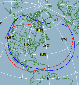
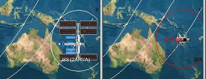
NOAA-16 coverage from New York |
Imagine if you could superimpose all the passes for a given
satellite for a week or a month ahead. You would end up with a plot
showing the coverage from your location. This simple program allows you to
do just that, and provides a text file of the results for any further processing
you wish to make. Experimental, unsupported program. Requires the SGP-4
component V3.2.0 listed below.
The screen shot to the left shows the coverage to be expected from an HRPT
station located in New York. Note the differences between north-bound
and south-bound coverage shown as red and blue lines. |
| V1.0.6 |
Add gnomonic
projection. |
| V1.1.0 |
Build with Delphi 2009 |
Do you want to use the same prediction code as in WXtrack? Perhaps
you want to call it from Visual Basic, Visual C++, Visual C#, Java, a Web page, or even a batch file.
This component is for you! I have made available the core SGP4 model
satellite prediction routines used in WXtrack as an Active-X DLL component. This allows you to
call satellite prediction routines from any program, Web pages using ASP, or even from the
command line by using the Windows Scripting Host. Working samples are provided
showing how to obtain a list of passes with Microsoft Visual Basic, Visual C#, Visual C++, Borland's
Delphi, using
the Windows Scripting Host and using Active Server Pages.
As in
WXtrack, the core code is from Dr T S Kelso's Pascal implementation of the highly accurate
SGP4/SDP4 orbital model. Many thanks to Dr T S Kelso for making this code available.
| V3.2.0 |
Add access to
satellite state.
2002 Apr 05 Updated Les Hamilton's VB5 demo.
2003
Jan 15 documentation update. |
| V3.4.0 |
Add Period function and access to Kepler data,
add MeanAnomaly to Kepler data, add MakePassDetails function.
2005 Feb 26
- updated Les Hamilton's VB5 demo.
2005 May 31 - added Nadir's C# demo.
2005 Jul 18 - updated Les Hamilton's VB5 demo to demonstrate the MakePassDetails
function. |
| V3.5.0 |
2005 Jun 16 - fix memory leak with duplicate satellite names.
2005 Jul 17 - increase error-checking in MakePassDetails (where a direction other than N, n, S, s is specified,
where the satellite name is mis-spelt).
2005 Jul 17 Les Hamilton updated the VB5 demo
(V6.0 update to make use of the function 'MakePassDetails'). |
| V3.6.0 |
2006-Sep-02 - add function MakePassDetails2
which includes the range rate.
2006-Sep-13 - add Java class and demo project from Henk Marais.
2007-Jan-15 - update Les Hamilton's VB5 demo.
2009-Jun-07 - restore C# demo.
2011-Mar-17 - add note about needing Administrator mode for REGSVR32 with
Windows-7.
2020-Apr-29 - Add VB.Net demo from (name lost).
2020-May-05 - Added note to C# demo how to return values in degrees rather
than radians - thanks: Gerhard Schweizer. |
This is exactly the same core code as used in WXtrack, but is provided
without support. Scott Hather is using a version of this DLL in the current version of his
SatScape software.
Note for Windows-7 users
If you are running Windows-7, you must be in Administrator
mode to register the DLL with Windows. You can get an Administrator mode
command prompt as follows:
- Start menu, All programs, Accessories, Command prompt
- Right-click, Run as Administrator
Then navigate to the directory containing DJTSatLib.dll and
enter the command:
REGSVR32 DJTSatLib.dll
If you get an 0x80004005 error message, you were not in
Administrator mode.
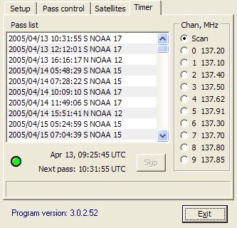 |
If you have an R2FX, R2ZX, R139 or RX2 receiver, you may have wanted to control it from
your computer so that important passes were collected, and not ruined by other
satellites capturing the receiver. My PassControl program allows this
scheduling, and being RS232-based, it works under Windows XP, 2000, NT etc. as
well as Windows 98 and ME.
This program has been fully updated for the new GEO
PIC 1.0 and for Kepler data for NOAA-18 & NOAA-19.
Hardware requirements: an R2FX,
R2ZX, R139 or RX2
Receiver modified for serial
remote control.
|
| V3.1.0 |
Support GEO's R2FX (standard) and R2ZX (pager-proof)
receivers - from the GEO Shop. |
| V3.2.2 |
Support NOAA-19. |
| V3.2.4 |
Update for proposed NOAA-18/NOAA-19
frequency swap. |
| V3.3.2 |
Update for NOAA-15/NOAA-17 frequency swap. |
Please note: If you are upgrading PassControl under Windows 2000, the first time you run the program you may get an error dialog box, possibly
with the message "Catastropic error". This error will go away once a valid location for the Kepler data is entered. Note that Windows 2000 is not a
supported version.
Now have their own page - please click this link. |


