


|
|
|
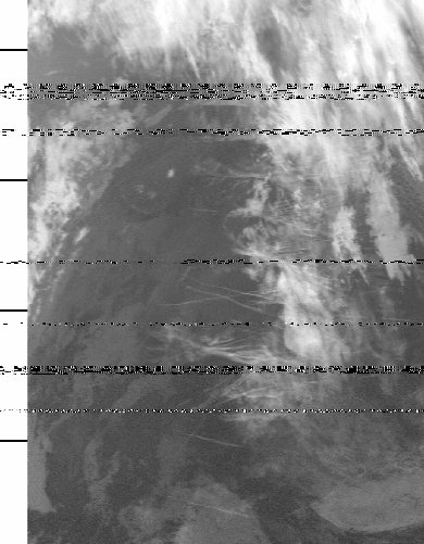
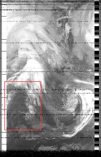
So can you help with this one? For sometime now I have been aware of trails on my pictures, which seem to be particularly noticeable around 04:00 to 05:00 UTC (picture time). I can't decide if they are aircraft trails or ship trails, but in any case they show up as a light colour in the infra-red, so I presume they are colder than their surroundings. I am also puzzled by the fact that the trails seem to be confined to a rather limited range of ocean. I would appreciate an explanation if you have one. (The horizontal bands are, I believe, interference from page systems which operate on the same frequency band here in the UK. I live at a "good" VHF location, so am surrounded by commercial antennae!). e.g. NOAA 14 southbound pass on 1999 Feb 24, starting at 04:53. Here is the image, reduced by a factor of three, showing the area where these trails appear outlined in red, and a full scale enlargement of the area. I've also included a sample output from my image generation program, which is under development, and you can see that with my simple kit I don't get all the pass. Look for the coastline of Norway to orient yourself. This sample output is also one third full-size. Thanks to everyone who has replied - these are now confirmed as aircraft trails (contrails) which can occur when the moisture content and other conditions are just right. There's a very interesting aircraft trail picture here, in which the trail is quite thick as the aircraft was circling, and the very low angle of the sun has resulted in a shadow some 50km away just off John o' Groats! Most likely the circling is caused by military mid-air refuelling exercises, or possibly electronic surveillance. More information on image interpretation Further reading recommended by Ben Huset:
Some comments on ships and ship-trails by Jacques d'Avignon: By chance I found myself on your web page this afternoon and read with great interest the trail puzzle story.
Let me tell you about something similar that I observed many many moons ago.
I installed the first commercial APT system in Canada, I believe that it was in 1967, 68 or 69 (memory is faulty at my age).
The satellites received were for APT Nimbus and Tiros, and the experimental stationary WEFAX off the west coast of South
America. (Elevation angle for WEFAX was 1 degree over the horizon.) The weather ships were "cruising" in a very narrow station: 210 miles and each smaller square, identified by a set of letters added to the NDB ID, was only 10 by 10 miles. So this means that the "OS" square (on station square and centre square) was only 100 square miles. Lets remember that at that time GPS did not exist and the only long range navigation system available was LORAN A operating around 1.8 MHz. So staying on station was a feat. Check this link for a full story on the Ocean Weather Ships.
|
|
|