


|
|
|
|
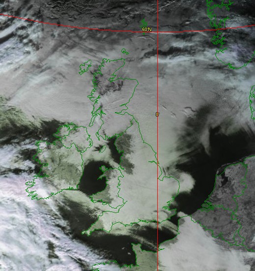
Weather Satellite DecodingOver Christmas 1998 I decided to act on a long-term but dormant interest that I have, remote imaging. I had purchased a scanner, the Icom IC-R2, again something that I'd been intending to do for a long time, but never actually got around to doing. The IC-R2 is a great box, with lots of opportunities to listen to aircraft and so on. I soon realised that it could also receive weather satellites that are in polar orbit, and transmit their data on VHF using Automatic Picture Transmission (APT) and on UHF using High Resolution Picture Transmission (HRPT). Once I discovered free decoding software on the Internet I was set and I got my first results. I've now added more sets of results including the recent Hekla eruption, the 1999 total solar eclipse, and a radar image of Norway. Roger Ray supplied the image on which this aircraft trail picture is based. The trail is quite thick as the aircraft was circling, and the very low angle of the sun has resulted in a shadow some 50km away just off John o' Groats! Some other puzzle pictures included a cloud effect over Iceland, outlines looking like image-processed pictures, and some radar images! However I experienced severe problems with interference from very local pager transmissions (this is mainly a UK issue) and I've put together a few notes on how I've managed to reduce the problem to an acceptable level. My Helical Resonator Notch Filter has helped attenuate near-band interference without reducing the wanted signal significantly. However even that cannot eliminate the interference to NOAA-15 caused by the NOAA-9 satellite switching itself back on! You can also see some recent results following the changes, including some pictures from the 1999 total solar eclipse and the 2006 total solar eclipse. Towards the end of 2001, I discovered that you could get data from geostationary satellites over the Internet, without needing the dish antenna and microwave receiver for direct reception, so I added the GeoSatSignal program to my suite that produces both still pictures and weather movies from geostationary data. Recent still images and animation results from that program are here. This has now lead to me installing a satellite receiver for the transmission of Meteosat-8 (MSG-1) and other data over DVB, a system called EUMETCast, writing the MSG Data Manager and MSG Animator programs to interpret that data. In mid 2006, the EUMETCast data was extended to include AVHRR high-resolution data, so you don't need a steerable antenna any more to get the wonderful HRPT images! Please also take a look at my Weather Satellite software page where there are program for tracking, APT decoding, geostationary decoding, and HRPT decoding. I have also provided a write-up of the inner workings of the software for those who are interested. Tell me more - can I meet up with like minded folk?If you want to know more about Weather Satellites, and remote imaging in general, do take a look at GEO's Web page (the Group for Earth Observation) and join the group. They run the GEO Shop where you can get those difficult-to-obtain items at a good price for members, and they run an annual symposium where you can meet other members. If you are in the Netherlands, please take a look at the Kunstmanen Web site (and in Dutch). They run meetings every two months where all are welcome There are a couple of mailing list groups out there - for GEO members there is the GEO-subscribers group, and to get weekly status reports on weather satellites you can join the Weather Satellites Reports group. Both of these groups are well served with subscribers and are excellent places to ask questions. If you want to know more about remote sensing you can take a look at the Remote Sensing Tutorial. GEO - the Group for Earth ObservationHere's what the Director General of EUMETSAT, Dr. Lars Prahm, said about GEO: "EUMETSAT through its provision of meteorological satellites represents a key
component of the Global Observing System. EUMETSAT as a European satellite
operator and data provider plays a crucial role in the delivery of environmental data which is used for all forms of meteorology and climate
monitoring. In a time where we more frequently see the impact of climate change in our every day lives, the GEO members' contribution, in bringing
Earth observation data to the man-in-the-street is most welcome. GEO has made a
significant contribution to the success of the “low cost” EUMETCast reception station - I know that many members of GEO swell our ever
increasing numbers of private users of Meteosat and Metop data and products.
Your interest, enthusiasm and passion for satellite imagery and all forms of Earth observation data is clear to see. |
|
|