


|
|
Information
WXtrack en français WXtrack has four screens, Setup, World Map, Ground Track and Flight, which are accessed by means of a tabbed page control. On first running the program, you will be presented with the Setup screen, although in normal use the World Map will be the first to display with a real-time presentation of your chosen satellites. Setup
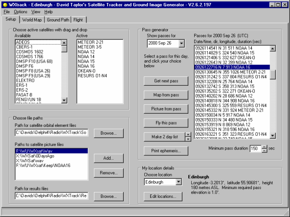
Initial setupThere are few things to configure when first using WXtrack, your favourite satellites and your location. The program is provided with a set of two-line element files which were current at the time the archive was prepared, but you can use your own files (with .TLE or .2LI file extensions), and you can specify where the files live so that they can be shared with other programs which use orbital data. Drag and drop the satellites you want to monitor from the Available list to the Active list. You should then set up your My Location details, which is initially set to Edinburgh, but you can click on the Edit locations... button, and give your location as decimal degrees of latitude and longitude. West of Greenwich or south of the equator the figures will be negative. Clicking on the Make pass list button should then give you a list of passes for your chosen satellites at your location (shown above for predicting 2 days ahead - you can actually predict up to 28 days on this screen, and 3 months ahead with the Ephemeris). Finally, if you want to compare ground maps with actual satellite images you have, you should enter one or more paths to the satellite images. These must be named in accordance with the WXSat convention, although a variety of suffices and file types (BMP, PNG and JPEG) are allowed and these are described in the documentation. Routine interactionYou would normally make use of the Setup tab to determine which satellite you want to have as your primary satellite on the next tabs. You can select a pass from the list (and as you alter the date the list for the day will appear after a short delay - the delay is to avoid excessive flicker, by the way). Once you have selected a pass, you can click on either the Map from pass or Picture from pass buttons to got to those tabs, with the satellite and date/time of your choice pre-loaded. A quick shortcut to the Ground Path tab with the pass details pre-loaded is to double-click on a pass. Note that all times are in UTC, and the program uses the setting you make in the Windows Control Panel for Time Zone information to convert your computer's clock time to UTC, so please make sure this information is correct! World Map
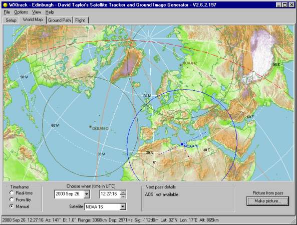
The first screen you will normally see is the World Map tab. This presents the path of your chosen satellites over the previous five minutes, with a dotted line showing the approximate sensor path of the "primary" satellite (NOAA 16 in the screen shot above). The footprints of one or more satellites can be displayed. Details of the satellite's location, signal strength The World Map display may be all that you desire from the program - it has some of the features of WinOrbit, but without the multiplicity of windows that make that program difficult to use. Ground Path
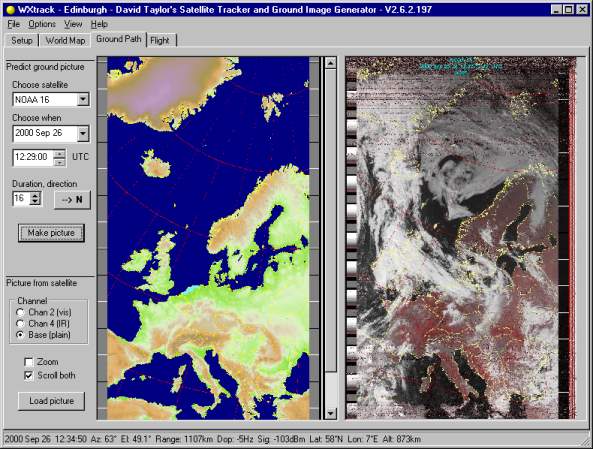
The main feature of WXtrack is the ability illustrated above, the prediction of the image that a pass should produce. The program allows you to put side-by-side the predicted image with an actual satellite pass so that areas that are unclear or cloud covered may be determined. Coming from the Make Picture button the details for the pass will be filled in, but you can choose a different set of parameters If you don't get a satellite picture, most likely your pictures do not conform with the naming convention described in the documentation, or you haven't set up the paths for satellite images correctly. You can choose the visible or the infra-red channel, and you can zoom both images. The predicted and actual images may not coincide exactly - not because of any program error, but Next: SatSignal |
|
|