


|
|
|
SatSignal can be used interactively, but comes into its own for automated operation, so that you might want to write some batch files like the ones I've shown below. These use the Windows NT extended command syntax to enable all wave files in a folder recorded by WXSat to be processed. The only thing that the program cannot determine is the satellite direction, so two separate batch files are provided for northbound and southbound passes. These batch files each strip the ".wav" file extension, then call a processing file for each wave file discovered, and the processing file checks for any existing JPEG files before starting processing. Note that I use different wave files for Resurs, NOAA etc. as I find that each satellite gives best decoding results at different sampling rates, and you may wish to have a different gamma or interpolation policy. This is one area where SatSignal differs from WXSat in not having a number of recallable parameter sets. ResursNorthbound.bat@echo off for %%i in (0*.wav) do call ResursProcess.bat %%~dpni N for %%i in (1*.wav) do call ResursProcess.bat %%~dpni N ResursSouthbound.bat@echo off for %%i in (0*.wav) do call ResursProcess.bat %%~dpni S for %%i in (1*.wav) do call ResursProcess.bat %%~dpni S ResursProcess.bat@echo off if NOT exist %1.jpg SatSignal.exe %1.wav %1.jpg %2 F=11038 G=1.8 if errorlevel 1 echo Failed to process %1.wav @echo off
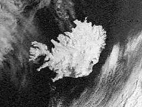
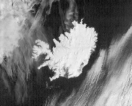
Interpolation ResultsPerhaps one of the most exciting aspects of SatSignal is the ability to extract rather more information satellites such as Meteor and Resurs. These satellites transmit two images per second rather then the four of the NOAA series (taking both channels into account), so there is proportionately more bandwidth available for the image. This results in a somewhat higher horizontal resolution that vertical resolution (which is limited by the satellite travel speed and the number of scans per second). Within SatSignal this resolution can be traded off to produce an image with about twice the number of pixels, by estimating lines in between the received image lines, and adjusting the number of pixels horizontally to maintain the correct aspect ratio. If you think this sounds too good to be true, check out the two pictures below and make you own judgment....
Next: GeoSatSignal |
|
|