|
| |
GRIB Viewer
What the users have said:
- I'm pleased that you were able to work with us and develop your software to process additional information which will be
useful for our forecast operations as the National Meteorological Service for the Isle of
Man - Alan Hisscott Senior Meteorological Officer Isle of Man Meteorological
Office.
- Thank you very much, the results are splendid. Your
GRIB Viewer is a very useful piece of software - Nicola Sebastiani,
Alessandria, Italy. http://www.scsebnic.net
 Download the GRIB Viewer
 Register the
GRIB Viewer
- please help support continued development Register the
GRIB Viewer
- please help support continued development
What is the GRIB Viewer?
The GRIB Viewer version 2 visualises the GRIB data broadcast over the
DWDSAT system, and data from the Norway & Danish and Météo France OSI-SAF
broadcast over EUMETCast. You can also visit the Yahoo
DWDSAT group to exchange ideas with other DWDSAT users, and the MSG-1
self-help group to discuss EUMETCast data products.
What data does it read?
- DWDSAT GRIB data available from the EUMETCast system (as used for
Meteosat-8/9 reception). Most data is free, however you still need to
register with DWD (or perhaps EUMETSAT). Some DWDSAT data is a separately paid-for
service from DWD.
- Norway and Denmark OSI-SAF
sea-ice products
- Sea-ice edge, type and concentration, in 10 km
resolution polar stereographic grid covering the Atlantic part of the
Arctic broadcast over EUMETCast (S-OSI_-NOR)
- Northern hemisphere sea-ice over FTP (ICE_CONC_NH)
- Southern hemisphere sea-ice over FTP (ICE_CONC_SH)
- Météo France OSI-SAF products
- Low and Medium Latitudes Downward Longwave Irradiance (LML
DLI)
- Low and Medium Latitudes Solar Surface Irradiance (LML
SSI)
- Low and Medium Latitudes Sea-Surface Temperature (LML
SST)
- Merged Atlantic Products Downward Longwave Irradiance
(MAP DLI)
- Merged Atlantic Products Solar Surface Irradiance (MAP
SSI)
- North Atlantic & Regional seas Sea-Surface
Temperature (7 areas) (NAR SST)
- Selected UK Met
Office DPDS data
- EUMETSAT MPE (Multi-sensor Precipitation Estimate) data
available over EUMETCast and online
here.
There are 2/4 files per hour per satellite; each file is about 800 KB
size. This data covers both the Meteosat-7 (Indian Ocean) and
Meteosat-8/9 (Europe, Africa and some South America) regions. More
information about EUMETSAT products.
- EUMETSAT CLAI (cloud analysis image), CTH (cloud-top
height), and DIV (divergence) data sent over EUMETCast.
- GRIB files produced in connection with the MaxSea
service.
What do the results look like?
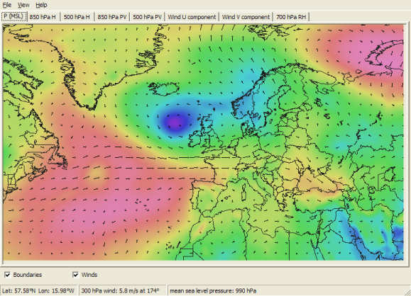
Sample from the DWDSAT data stream
Can I register and what do I get?
The program as downloaded provides a 30-day trial licence
period to allow you to evaluate its function. After the 30-day period, you
will need to register to continue running the program.
Please note that the products on the current EUMETCast stream
are subject to change, so please be sure that the program supports the data you
are interested in before purchase. There is a trial licence included in
the free download to enable you to check this!
| V4.0.2 |
More choice of boundary colours from the
command-line (-BOUND:<none|black|dark|light|white>), add
annotation to snapshot for MPE data, add scale to DIV data and the
snapshot, support BZ2 files, limited support ICON TOT_PREC, WW and VMAX
files.
|
| V4.0.2 |
Support H-SAF H15 data.
For existing users, if you don't have a GRIB Viewer 4
key, you can purchase a licence upgrade here.
|
-
Download the GRIB Viewer V4.0.4 (1,825,456 bytes;
2016-Sep-26)
MD5 signature: 037FA2052876A882D8EB2680A5419B1A
- Visit the SatSignal
self-help group to discuss this software with other users
- Please note that this download includes a 30-day trial of the full
GRIB Viewer. If you don't register within 30 days the
program ceases working.
-
Register
the GRIB Viewer - please help support continued development
- If you don't already have my runtime Library
Bundle, please download and install it (do this if you get messages
about missing DLLs when trying to run the program).
- For country outlines, you can use the file Countries.dat,
which may already be on your PC or you can download it here
(460KB).
|