


![]()


|
|
SatSignal
What is SatSignal?
|
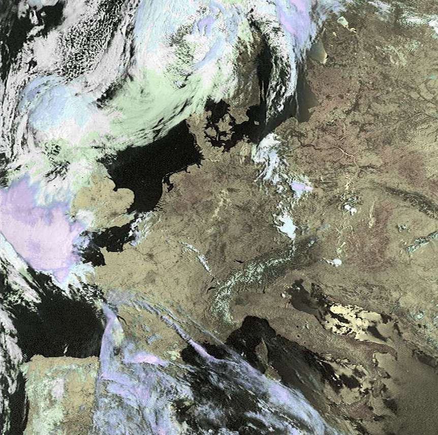
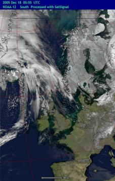
| Here is an example of the new Background
Overlay mode. By skilfully blending the temperature information
derived from the thermal channel with the recently released Blue
Marble Next Generation images of the earth, night-time images can be
presented looking as if they were daytime ones, with an attractive blue
sea background and naturally coloured land areas.
You have full control of what background images are used, so you are not restricted to the Blue Marble data. You also have full control over the blending process, so you can show colder clouds as light (as in the example here) or dark for a more dramatic presentation. Files to get you started are provided. |
 |
 |
| Channel B - thermal image with
conventional display. Click for larger image |
False colour Background Mode with Blue
Marble background image. Click for larger image |
Users have asked to support this software by registering, so I have now provided this facility. There are a number of extras for registered users including map overlays, input from bitmap (.BMP) image files, and the direct display of apparent temperature. These are available upon registration. I would also like those who use the program as a regular part of automated signal reception to consider registering, hence the toolbar and batch operation are included in the registered program. Click here for more information about registering SatSignal.
Please note that SatSignal 6 requires a new licence code.
If you get error messages about missing DLLs when you try to run SatSignal, please consult the library notes page.
Convert your SatSignal images to standard map projections with the GroundMap program
| V5.1.0 | Allow choice of mouse scroll direction,
French language update. 2008-Feb-29 Russian language update. |
| V5.1.2 | Add gamma 0.6 and 0.8 options for improved
cloud structure detail, refine WXtrack needed message, French language
update. 2008-Dec-07 Russian language update |
| V5.1.4 | Update NOAA-19 support, improved telemetry decoding, add check against bad Sensor Model value. |
| V5.2.2 | Default satellites updated, improved channel switch reporting, built with Delphi 2009. |
| V6.0.0 | Updated licence. |
![]() Download SatSignal V6.0.0
Download SatSignal V6.0.0
(1,638,741 bytes; 2015-Apr-07; MD5 signature: 2FF629D29757DEDFB7086D14AAE7D71B)
Beta version: Check here for the latest update.
Windows-7 and later information please read this is you have problems with the program's Help function.
If you like this software, you can rate it at the DXZone web site that lists related programs. Rate this Software @ The DXZone. Be sure to register SatSignal and support continued development.
A self-help group is available for this software here:
![]() Download LUTmaker 1.0.6 (31,424
bytes; 2001 Dec 12)
Download LUTmaker 1.0.6 (31,424
bytes; 2001 Dec 12)
| V1.0.4 | Is a companion program for building your own colour look-up tables to use with SatSignal. |
| V1.0.6 | Adds a Save As option. Includes source code. |
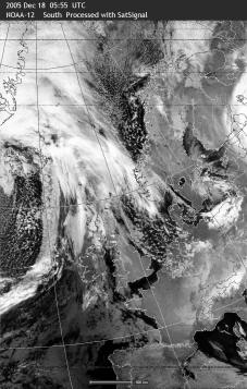
The sample images give an idea of the program's capabilities, but the large images are only one quarter of full size and do not give a fair impression of the quality of the program's output. Typically, each full-size Meteor or Resurs picture would decode to either 1 MB JPEG or 3 MB BMP files. The two pictures of Iceland are full scale, and were taken within an hour of each other on 1999 April 1. The NOAA image showing better contrast on the mountains, either because of the lower sun angle of the earlier picture or the stronger gamma correction of SatSignal, but with the higher resolution is achieved by Meteor with SatSignal, the higher elevation of Meteor also producing a lower noise signal.
Program to drive the SatSignal and WXtrack programs for automated decoding of a folder full of mixed satellite wave files.
Requirements
The registered version of SatSignal is required to run this program. No new libraries are required. A Pentium 200MMX processor or better is recommended, with at least 32MB of memory.
Current release
| V1.8.0 | Add support for NOAA-18 and NOAA-19, honour Windows XP themes. |
| V1.8.2 | Allow user control of minimum pass duration to be processed, pass NOAA-18 as model name when appropriate, add NOAA-6 to deselection options. |
| V1.8.4 | Add NOAA-APT only option. |
| V1.8.5 | Improved clarity of pass-list display. More choices with pass duration required .. be sure to check your "Require xx secs" setting. |
| V1.9.0 | Version for Delphi 2009. |
![]() Download SatBatch
V1.9.0 (532,807 bytes; 2009 Jun 30)
Download SatBatch
V1.9.0 (532,807 bytes; 2009 Jun 30)
The program reads pass details from both WXtrack and SatSignal and plots the signal quality as a function of the range and bearing from your location. By building up such data over a sequence of satellite passes, you can build up a picture of the antenna polar diagram, and detect any nulls in the polar diagram. It is also possible to compare antennas, and an example of such a comparison may be found here.
This is a free, unsupported utility. Please ask questions in the SatSignal self-help group.
Current release
| V1.2.0 | Provide "good signals only" scale range option, add smoothing option for Azimuth plot, add visual scale for polar plots. |
| V1.3.0 | Add save of estimated horizon data derived from least elevation seen in polar plot. |
![]() Download NOAAplot
V1.3.0 (62,113 bytes; 2006 Jun 25)
Download NOAAplot
V1.3.0 (62,113 bytes; 2006 Jun 25)
|
|