


![]()


|
|
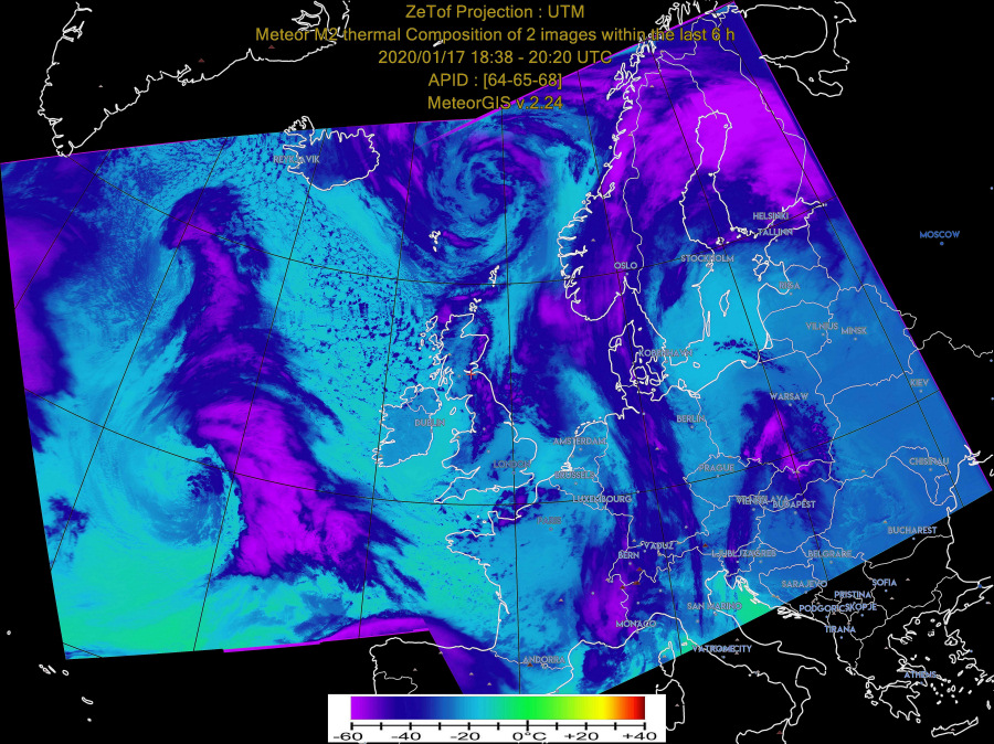
Automating Meteor-M N2 receptionI recently started playing with Meteor-M N2 reception. The lack of country boundaries was annoying, so I tried writing my own program to overlay boundaries, but it wasn't as accurate as I would like. Then I mentioned this to Douglas Deans (@GM4VZY on Twitter) who pointed me to this site http://happysat.nl/Setup_Meteor/Setup.html where all is explained, including completely automated reception. However, like others I found the information rather overwhelming at first scan, and it took a little while to get it all working. And the day after it stopped, after I made one small change. Arrgh! Working now, though. Apply the well-known advice - "If it works, leave it!". These are my own notes, with my own errors. Please help me to correct them!
HardwareYou need an antenna, a 137 MHz SDR receiver compatible with SDR#, and a PC. With PCs these days I suggest at least 8 GB memory and a quad-core processor. All the below is based on Windows 10.
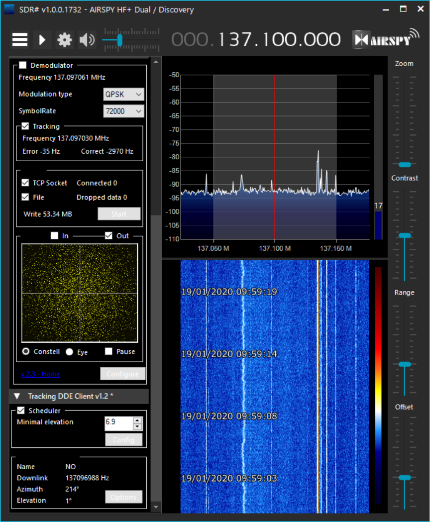
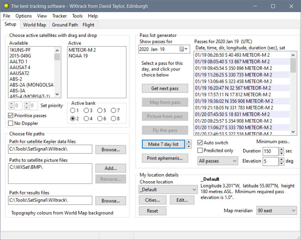
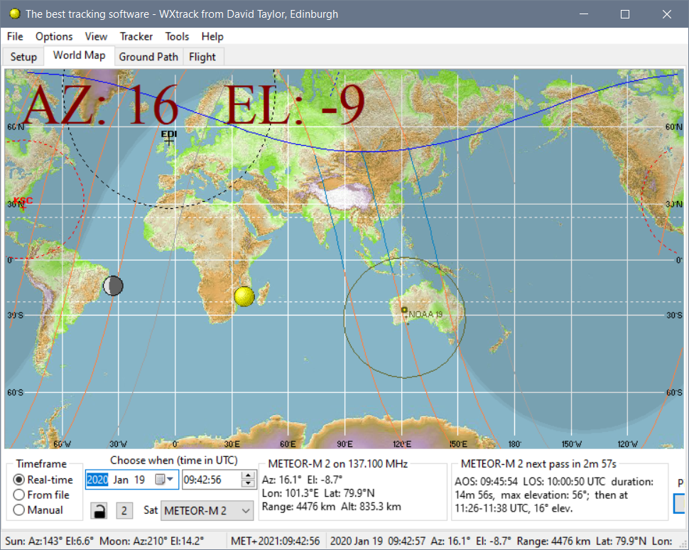
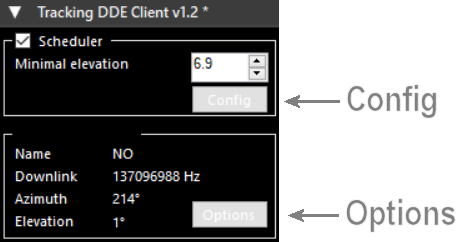
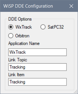
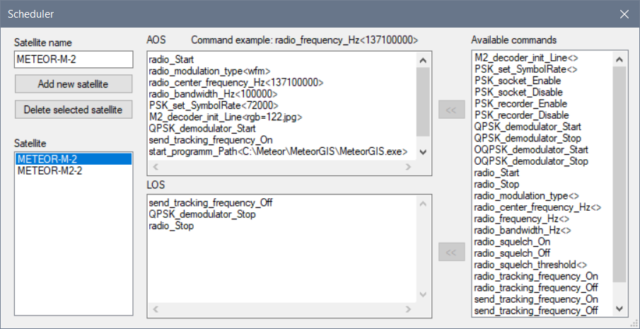
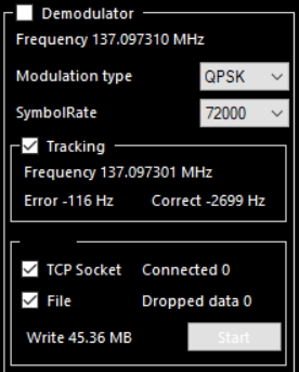
SoftwareSDR#, the Meteor plug-in, the Tracking DDE Client plug-in, tracking software such as WXtrack (or Orbitron), LRPT Decoder, MeteorGIS. All free (although there are extra facilities in the registered version of WXtrack). Ensure that you can use your dongle with SDR# to receive on 137.1 MHz. Set up the DDE plug-in according to the instructions on the HappySat site.
Processing operation - the steps involvedI found this one of the more poorly explained aspects. It's not complicated, and perhaps I simply haven't yet found the best Web site. Graham Hunter, VK4KGG, [GH] has kindly provided some additional notes included below in edited versions and tweaks throughout the description.
While waiting for a pass....
Configuring the softwareNightly restartsWXtrack must be running, and if your PC runs continuously, you need to stop
and restart WXtrack and SDR# over midnight, e.g. at 01;20 UTC. You can
create a script to do this and schedule it to run at a convenient time.
For example:
|
C:\Tools\ ├───Satsignal │ └───WXtrack ├───NTP └───SDR# |
C:\Meteor\ ├───Images-M2 │ └───2020 │ └───01 │ └───02 etc. ├───MeteorGIS │ └───file_to_put_in_M2_LRPT_Decoder_folder ├───out-images-M2 └───S_files |
C:\Meteor\
│   M-N2.2_cfg.jpg
│   M-N2_cfg.jpg
│   M2-2.txt
│   M2.2_tle.txt
│   M2_LRPT_Decoder.exe
│   M2_LRPT_Decoder.ini
│   M2_LRPT_Decoder.txt
│   M2_LRPT_Decoder.zip
│   M2_LRPT_Decoder_for_s.ini
│   M2_LRPT_Decoder_georef.ini
│   M2_LRPT_Decoder_man-m2-2.ini
│   M2_LRPT_Decoder_man-m2.ini
│   M2_LRPT_Decoder_TCP-m2-2.ini
│   M2_LRPT_Decoder_TCP-m2.ini
│   M2_LRPT_Decoder_TCP_80K-m2-2.ini
│   M2_tle.txt
│   run-geo.bat
│   run.bat
│   SGP4.dll
│   V53.jpg
│
├───Images-M2
│   │   comp-UTM-2020-1-19-9-49-45-771_IR.jpg
│   │   comp-UTM-2020-1-19-9-49-45-771_IR_rainfall.jpg
│   │   comp-UTM-2020-1-19-9-49-45-771_RGB.jpg
│   │   comp-UTM-2020-1-19-9-49-45-771_RGB_rainfall.jpg
│   │   comp-UTM-2020-1-19-9-49-45-771_thermal.jpg
│   │   thumb_comp-UTM-2020-1-19-9-49-45-771_IR.jpg
│   │   thumb_comp-UTM-2020-1-19-9-49-45-771_IR_rainfall.jpg
│   │   thumb_comp-UTM-2020-1-19-9-49-45-771_RGB.jpg
│   │   thumb_comp-UTM-2020-1-19-9-49-45-771_RGB_rainfall.jpg
│   │   thumb_comp-UTM-2020-1-19-9-49-45-771_thermal.jpg
│   │   thumb_UTM-2020-1-19-8-10-33-710_IR.jpg
│   │   thumb_UTM-2020-1-19-8-10-33-710_IR_rainfall.jpg
│   │   thumb_UTM-2020-1-19-8-10-33-710_RGB.jpg
│   │   thumb_UTM-2020-1-19-8-10-33-710_RGB_rainfall.jpg
│   │   thumb_UTM-2020-1-19-8-10-33-710_thermal.jpg
│   │   thumb_UTM-2020-1-19-9-49-45-771_IR.jpg
│   │   thumb_UTM-2020-1-19-9-49-45-771_IR_rainfall.jpg
│   │   thumb_UTM-2020-1-19-9-49-45-771_RGB.jpg
│   │   thumb_UTM-2020-1-19-9-49-45-771_RGB_rainfall.jpg
│   │   thumb_UTM-2020-1-19-9-49-45-771_thermal.jpg
│   │   UTM-2020-1-19-8-10-33-710_IR.jpg
│   │   UTM-2020-1-19-8-10-33-710_IR_rainfall.jpg
│   │   UTM-2020-1-19-8-10-33-710_RGB.jpg
│   │   UTM-2020-1-19-8-10-33-710_RGB_rainfall.jpg
│   │   UTM-2020-1-19-8-10-33-710_thermal.jpg
│   │   UTM-2020-1-19-9-49-45-771_IR.jpg
│   │   UTM-2020-1-19-9-49-45-771_IR_rainfall.jpg
│   │   UTM-2020-1-19-9-49-45-771_RGB.jpg
│   │   UTM-2020-1-19-9-49-45-771_RGB_rainfall.jpg
│   │   UTM-2020-1-19-9-49-45-771_thermal.jpg
│   │
│   └───2020
│       └───01
│               2020-1-19-11-30-58-134.70
│               2020-1-19-11-30-58-134.vcdu
│               2020-1-19-11-30-58-134_122.jpg
│               2020-1-19-11-30-58-134_122.jpg.gcp
│               2020-1-19-11-30-58-134_122.jpg.stat
│               2020-1-19-11-30-58-134_64.bmp
│               2020-1-19-11-30-58-134_64.stat
│               2020-1-19-11-30-58-134_65.bmp
│               2020-1-19-11-30-58-134_65.stat
│               2020-1-19-11-30-58-134_68.bmp
│               2020-1-19-11-30-58-134_68.stat
│               2020-1-19-8-10-33-710.70
│               2020-1-19-8-10-33-710.vcdu
│               2020-1-19-8-10-33-710_122.jpg
│               2020-1-19-8-10-33-710_122.jpg.gcp
│               2020-1-19-8-10-33-710_122.jpg.stat
│               2020-1-19-8-10-33-710_64.bmp
│               2020-1-19-8-10-33-710_64.stat
│               2020-1-19-8-10-33-710_65.bmp
│               2020-1-19-8-10-33-710_65.stat
│               2020-1-19-8-10-33-710_68.bmp
│               2020-1-19-8-10-33-710_68.stat
│               2020-1-19-9-49-45-771.70
│               2020-1-19-9-49-45-771.vcdu
│               2020-1-19-9-49-45-771_122.jpg
│               2020-1-19-9-49-45-771_122.jpg.gcp
│               2020-1-19-9-49-45-771_122.jpg.stat
│               2020-1-19-9-49-45-771_64.bmp
│               2020-1-19-9-49-45-771_64.stat
│               2020-1-19-9-49-45-771_65.bmp
│               2020-1-19-9-49-45-771_65.stat
│               2020-1-19-9-49-45-771_68.bmp
│               2020-1-19-9-49-45-771_68.stat
│
├───MeteorGIS
│   │   About_.s.txt
│   │   ChangeLog.txt
│   │   CLUT.png
│   │   default.ini
│   │   default.ini.bak
│   │   defaultENG_configurator.mgis
│   │   EGIS.ShapeFileLib.dll
│   │   geomutil_lib.dll
│   │   geomutil_libx64.dll
│   │   LemonMilk.otf
│   │   logs.txt
│   │   manual.ini
│   │   manual.ini.bak
│   │   Manual_M2_GIS.bat
│   │   MeteorGIS-default.ini.zip
│   │   MeteorGIS.exe
│   │   MeteorGIS_Configurator.exe
│   │   MeteorGIS_x86.exe
│   │   ne_10m_geography_regions_elevation_points.dbf
│   │   ne_10m_geography_regions_elevation_points.shp
│   │   ne_10m_geography_regions_elevation_points.shx
│   │   ne_110m_graticules_10.dbf
│   │   ne_110m_graticules_10.shp
│   │   ne_110m_graticules_10.shx
│   │   ne_50m_admin_0_boundary_lines_land.dbf
│   │   ne_50m_admin_0_boundary_lines_land.shp
│   │   ne_50m_admin_0_boundary_lines_land.shx
│   │   ne_50m_coastline.dbf
│   │   ne_50m_coastline.shp
│   │   ne_50m_coastline.shx
│   │   ne_50m_lakes.dbf
│   │   ne_50m_populated_places.dbf
│   │   ne_50m_populated_places.shp
│   │   ne_50m_populated_places.shx
│   │   ne_50m_rivers_lake_centerlines.dbf
│   │   passList.txt
│   │   RAIN.png
│   │   README.txt
│   │   thermal.ini
│   │   therm_pal.jpg
│   │   watermark.txt
│   │
│   └───file_to_put_in_M2_LRPT_Decoder_folder
│           SGP4.dll
│
├───out-images-M2
├───safe
│       2020-1-18-8-30-5-204_125.bmp
│       2020-1-18-8-30-5-204_125.bmp.stat
│       2020-1-18-8-30-5-204_64.bmp
│       2020-1-18-8-30-5-204_64.stat
│       2020-1-18-8-30-5-204_65.bmp
│       2020-1-18-8-30-5-204_65.stat
│       2020-1-18-8-30-5-204_68.bmp
│       2020-1-18-8-30-5-204_68.stat
│       2020_01_18_LRPT_08-27-01.s
│
└───S_files
        2020_01_17_LRPT_08-46-52.s
        2020_01_17_LRPT_10-27-20.s
        2020_01_17_LRPT_18-37-36.s
        2020_01_17_LRPT_20-17-36.s
        2020_01_18_LRPT_08-27-01.s
        2020_01_18_LRPT_10-07-19.s
        2020_01_18_LRPT_11-48-28.s
        2020_01_18_LRPT_18-18-08.s
        2020_01_18_LRPT_19-57-27.s
        2020_01_18_LRPT_21-40-59.s
        2020_01_19_LRPT_08-07-14.s
        2020_01_19_LRPT_09-43-06.s
        2020_01_19_LRPT_09-47-20.s
        2020_01_19_LRPT_11-28-17.s
|
[GH] I use separate folders for each program under a main level folder.
F:\Meteor\
    \MeteorGIS_v2.24
    \LRPTv56
    \SDR#v1731
    \Meteor_Demodulator_Recorder
    \Wxtrack (or Orbitron)
    \Images
    \Imagesfinales
    \Thumbnails
    \Sharefolder
I’ve even included WXtoImg and its sub folders so all weather satellite
programs for automatic decoding are in the one main folder etc. The
advantage of this I’ve found is that with the release of a new version of
program, there’s relatively little changes to be made in configurations to
have the new version active, yet if it fails miserably, it’s easy enough to
revert back! Caveat Emptor!
|
|