DWDSAT HRPT Viewer
The DWDSAT HRPT Viewer is a program to allow with
visualisation of NOAA HRPT data being sent over EUMETCast as part of the DWDSAT
GDS (Global Data Set) service.
User comments
- "The program is working well and with the range of satellites taken by
DWD, is a real bonus to our HRPT quality imagery. Thanks again for getting it up and running so quickly.
Brilliant software and service." - Douglas Deans.
Functions
The DWDSAT HRPT Viewer combines a number of functions:
- Decoding of the TIFF and BZ2 data
- Loading up to 5 channels of HRPT and presenting them for
display
- Combining the channels to provide a false-colour display
- Combining the channels to provide an RGB display
- Combining the channels to show a vegetation index display
- Readout of the reflectivities, brightness temperatures, and
vegetation index at the cursor location
- Overlay of country boundaries and gridlines.
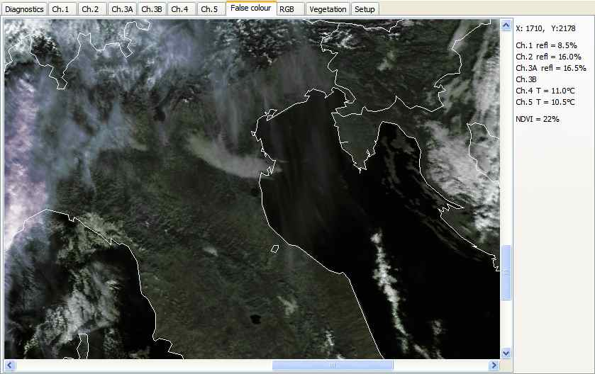
Screen-shot when running the DWDSAT HRPT Viewer
with NOAA-17 data from 2006 November 23. You can see the choice of
display tabs at the top of the screen-shot. The five basic channels are
displayed in greyscale. The false-colour option, shown below, combines and
attractive display with scientifically useful data. The RGB display brings
out the detail in the cloud whereas the False-colour display brings out the
detail in the land. The vegetation display uses the well-known NDVI
(normalised difference vegetation index) to show chlorophyll content by the
difference in its reflectivity at 0.6�m and 0.8�m. The north of the Adriatic
Sea and Istria are visible to the right side of the image.
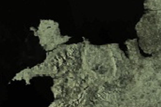
Here is an image derived from NOAA-15 data, when
the sun was at a low angle, and March 18 was an unusually clear day in the
Spring of 2009. It shows North Wales and the Liverpool area, and has been
enlarged by a factor of three after saving from the DWDSAT HRPT Reader.
There is more discussion about this image here.
Requirements
- The program works with NOAA DWDSAT HRPT data sent over the EUMETCast
data stream. You need to register with DWDSAT (free) to receive this
data. Select Data and Subscription fees and this will give you more information about how to register for DWD GDS
(Global Data Set) data.
- Files in both TIFF and BZ2 format are supported.
Example file names are like:
sat01-noa_k5_cenoa_p_000_000-0611230140-ofl.tiff
n18s0611232349.pl4.bz2
- A screen resolution of 1024 x 768 may be required to
operate this software.
- The program is supported on Windows 2000, XP and Windows
Vista, it
should work on Windows 2003 (but has not been tested), and may work on
Windows 9X as well (not recommended).
- A 500MHz PC with 512MB of memory is
the minimum requirement.
 Optional
country boundary data. Optional
country boundary data.
The Program in operation
There are a number of tabs in the main program display, and a
Show boundaries check-box.
Diagnostics
Information for initial debugging purposes
Ch.1 to Ch.5
Data from the satellite pass, as calibrated and ground
rectified by DWD. Note that channels 3A (near-IR) and 3B (mid-IR) share
the same downlink, so they will not both be present. This is not an
error.
False-colour
Provides a false-colour image using the classic SatSignal
colours which have proved so successful over the years. A visible
channel is used for the brightness of the image, and a thermal channel for the
colour of the image. Please note that the false-colour tab may not be
available if there are insufficient channels in the pass.
RGB
Provides an RGB display with the classic RGB 124 channel
mapping.
Vegetation
Provides a display showing the NDVI (normalised difference
vegetation index), derived from channels 1 and 2. Please note that the
vegetation tab may not be available if channels 1 or 2 are missing from the
pass.
Setup
The setup tab will allow you to match the program's data paths to
those of your system, and to customise a number of options.
- Please tell me what you want to see here.....
Suggestions for new users of this service
As this is a program for a recent EUMETSAT
service, I will try and build up the user guide as we go along, using the questions you ask as a starting point. If you have questions about the program, they may already
be answered in the general FAQs or the DWDSAT
HRPT Viewer
FAQs.
A self-help group is available for this service at Yahoo! Groups:
https://groups.yahoo.com/neo/groups/dwdsat/info
Download
| V1.1.0 |
Add control of line width selection for
boundary and grid lines, add choice of line colour for colour images.
|
| V1.1.2 |
Optional enhancements to the File|Open
dialog.
|
| V1.2.2 |
Add pixel location read-out, build with
Delphi 2009.
|
| V1.2.4 |
Accept externally decompressed file sets.
|
| V2.0.2 |
Investigate changed data from DWDSAT (header
format has changed from version 1 to version 2, image size now not
correctly found reading header, map projection parameters read
incorrectly, provide temporary fix until new header format known or DWD
correct).
|
Important: this program has built-in 30-day trial
licence. If you just want to try the program, please do not run the
program until you know you are receiving data! Once the trial 30-day
period has started, there is no way to reset it.
Register
- You can register the DWDSAT HRPT Viewer online here.
|